
About
The AFT project began as a pilot project (1998-2000) funded by the Andrew W. Mellon Foundation to test the use of remotely-sensed imagery, Geographic Information Systems (GIS), and spatial analysis to model the spatial and temporal variability in fertility in Egypt in both a rural setting (Menoufia Governorate) and an urban setting (central Cairo). The results obtained from the pilot phase were sufficiently promising to extend the research to include a broader geographic coverage. The AFT was then supported by the National Science Foundation (2001-2004) and its geographic scope was extended to other areas within Egypt, and also to urban and rural areas in Jordan.
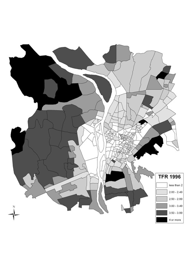
Fertility transition (1986-1996) in Cairo, Egypt Photo of TFR in Cairo
John R. Weeks, “Spatial Patterns of Fertility Change in Rural Egypt,” Chapter 17 in Luc Anselin and Serge Rey, editors, Perspectives on Spatial Data Analysis (New York: Springer Publishing Co.), 2010.
Tarek Rashed, John R. Weeks, Helen Couclelis, and Martin Herold, “An Integrative GIS and Remote Sensing Model for Place-Based Urban Vulnerability Analysis,” Chapter 9 in Victor Mesev, editor, The Integration of RS and GIS (New York: John Wiley & Son), 2007.
John R. Weeks, Dennis Larson, and Debbie Fugate, “Patterns of Urban Land Use as Assessed by Satellite Imagery: An Application to Cairo, Egypt,” Chapter 11 in Barbara Entwisle, Ronald Rindfuss, and Paul Stern, editors, Population and Environment (Washington, DC: National Academies Press), 2005.
Tarek Rashed, John R. Weeks, Douglas A. Stow, and Debbie Fugate, “Measuring Temporal Compositions of Urban Morphology through Spectral Mixture Analysis: Toward a Soft Approach to Change Analysis in Crowded Cities,” International Journal of Remote Sensing, 26(4):699-718, 2005.
John R. Weeks, Arthur Getis, Allan G. Hill, Tarek Rashed, and M. Saad Gadalla, “The Fertility Transition in Egypt: Intra-Urban Patterns in Cairo,” Annals of the Association of American Geographers, 94 (1):74-93, 2004.
John R. Weeks, “The Role of Spatial Analysis in Demographic Research,” in Michael F. Goodchild and Donald G. Janelle (eds.), Spatially Integrated Social Science: Examples in Best Practice (New York: Oxford University Press), 2004.
John R. Weeks, “Using Remote Sensing and Geographic Information Systems to Identify the Underlying Properties of Urban Environments,” Chapter 17 in Tony Champion and Graeme Hugo, eds., New Forms of Urbanization: Conceptualizing and Measuring Human Settlement in the Twenty-first Century (London: Ashgate Publishing Limited), 2004.
Tarek Rashed, John R. Weeks, Dar Roberts, John Rogan, and Rebecca Powell, “Measuring the Physical Composition of Urban Morphology Using Multiple Endmember Spectral Mixture Models,” Photogrammetric Engineering and Remote Sensing 69(9): 1111-1120, 2003.
Tarek Rashed, John R. Weeks, M. Saad Gadalla, and Allan G. Hill, “Revealing the Anatomy of Cities through Spectral Mixture Analysis of Multispectral Imagery: A Case Study of the Greater Cairo Region, Egypt,” Geocarto International, 16(4):5-16, 2001.
John R. Weeks, M. Saad Gadalla, Tarek Rashed, James Stanforth, and Allan G. Hill, “Spatial Variability in Fertility in Menoufia, Egypt, Assessed Through the Application of Remote Sensing and GIS Technologies,” Environment and Planning A, (32):695-714, 2000.
Project Team
PI – Dr. John R. Weeks
Co-PI – Dr. Saad Gadalla
Co-PI – Dr. Allan Hill
Co-PI – Dr. Douglas A. Stow
Co-PI – Dr. Arthur Getis
Graduate Student Researchers
Dr. Tarek Rashed, Dr. Debbie Fugate, Xiaoling Yang, Heather Davis, Jeffery Beyoghlow, and James Stanforth